|
Webinar DigitalGlobe: forest health |
|
This English webinar can be viewed here:
http://youtu.be/u1zeqA3w0GU
|
|
The webinar describes an analysis for Sveaskog and the Forest Agency to find sick and dying forests that contributed to the spread of bark beetles in Sweden. |
|
|
|
GIS Analysis, let experts in TerraNor assist |
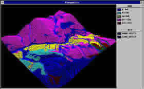
2D analysis presented in 3D |
|
TerraNor can offer a variety of GIS analyzes, such as: |
- overlay and buffer analyzes with link to property data
- network analyzes such as shortest distance, buffer and overlay
- combination of area and network analysis reclassification areas
- terrain analyzes with elevation, slope and aspect theme map
- the results are presented in text form and with visualization in 3D or regular 2D maps
- Linking maps and customer property tables opens up great opportunities
- advanced analysis and customization of data
- radio coverage map
|
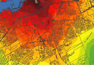
Radio coverage map, built with 3D model and shown in 2D. |
Facilitate data:
Analyzes require well-structured data. Data from Oracle Spatial, Geomatica, Arc Info
and the corresponding GIS will normally have good quality. TerraNor can organize data
before analyzes.
|